// 2026-08-20 · Maps & Exploration · by Bob Smith
Chronotrains: How Far You Can Get by Train From Anywhere in Europe
Chronotrains draws isochrones over Europe's rail network — hover any station and coloured bands show everywhere reachable in one to eight hours. Free, no account, built on Deutsche Bahn timetable data.
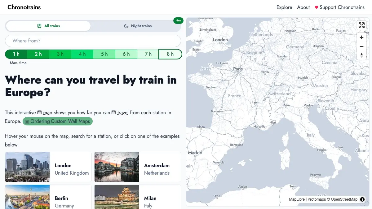
Chronotrains asks a question most journey planners refuse to answer. Not “how do I get from Paris to Turin”, which any booking site will handle, but the inverse: given five hours and a train station, where can I actually go?
Hover your mouse anywhere on the map of Europe and you get the answer immediately, as colour. A tight ring around the station for the first hour, then wider bands fanning outward — down high-speed corridors in long tongues, stopping dead at mountain ranges and coastlines, thinning to nothing where the rails run out. The shape of the network becomes visible in a way a timetable never makes it.
It is free, needs no account, and has been quietly getting better for four years.
What is Chronotrains?
Chronotrains is an isochrone map. The word means “same time”: every point on a given band is roughly the same number of hours away from where you started, the way a contour line joins points of equal height. Applied to rail, it turns a schedule into a geography.
Benjamin Tran Dinh, a developer based in Paris, built the first version and posted it in the summer of 2022, crediting Direkt Bahn Guru by Julius Tens as the inspiration. Then he went on holiday. By his own account in a write-up for Vercel, it reached the top of Hacker News, spread across Twitter, got cited by newspapers and politicians arguing about rail investment, and had passed a million visits by the time he came back. The site is now credited to Tran Dinh and Sarah Mamy.
The travel times come from Deutsche Bahn’s timetable data, reached through the API that powers Direkt Bahn Guru. Night train routes come from Back On Track, a European campaign group for sleeper services.
The interesting part is what happens to that data. Chronotrains builds a graph of European stations joined by journey durations, then explores outward from every station in turn to find what is reachable at each hourly threshold. Because local transit is not in the dataset, stations within 10 km of one another get an artificial link, traversed at 9 km/h — a walking-pace fudge that stitches a city’s separate terminals together. Interchanges are assumed to take 20 minutes flat. All of it is calculated ahead of time and stored as map geometry, which is why hovering feels instant instead of like a search.
The result is roughly 34,000 station pages, in 14 languages, sitting on top of a pre-computed answer to every version of the question.
What can you do with Chronotrains?
- Hover anywhere. Move the cursor across the map and the isochrones redraw from whatever station is nearest. No clicking, no form to fill in.
- Set a time budget. The slider at the top caps the map at anywhere from one to eight hours, which is the difference between “afternoon out” and “I will arrive in time for dinner somewhere foreign”.
- Search a specific station. Type a city and get its page — Berlin, Milan, Amsterdam and London are offered as starting examples on the homepage.
- Watch it grow. Individual station pages have an animated slider running from zero to twelve hours, so you can play the reach outward and see which corridors do the heavy lifting.
- Filter to direct trains only. A separate mode drops everything requiring a change, which is the honest view if you dislike connections or are travelling with luggage and children.
- Explore night trains. A dedicated night train map shows the sleeper network across Europe as its own layer, using the Back On Track data.
- Compare two cities. Flip between origins and the asymmetry of the network becomes obvious: some mid-sized cities reach further in four hours than capitals do.
- Book onward. Booking links point out to Trainline, SNCF Connect and Deutsche Bahn once you have picked a destination.
Tips to get the most out of it
- Start at the edges, not the middle. Hovering over Paris or Frankfurt gives you the expected huge blob. The map is more revealing from places you would not have guessed were well connected.
- Use the hour slider as a trip filter. Set it to three hours and hover around your home region — that is your realistic weekend-without-flying radius, drawn for you.
- Turn on direct trains for the real answer. A five-hour journey with two changes and a 20-minute assumption baked into each one is a very different proposition from a five-hour direct train.
- Read the gaps as information. Where the colour stops abruptly, it is sometimes terrain, sometimes a border with no through service, and sometimes just missing data. Knowing which is which is half the fun.
- Check the actual timetable before committing. The site is explicit that these are estimates; frequency is not shown at all, so a route that looks reachable may run twice a day.
What it does not do
Chronotrains is a picture of possibility, not an itinerary. The times assume you catch every connection with 20 minutes to spare, and say nothing about whether the train runs on a Sunday, at 6am, or at all this month. Coverage follows the source data, which means it is strongest in central Europe near routes Deutsche Bahn operates or co-operates with, and gets patchy the further out you go — smaller regional operators often simply are not in the feed. Bellingcat’s toolkit entry, which recommends the site for verifying travel claims, notes that Bosnia and Herzegovina, Albania and Belarus have no data, Russia none, and Turkey, Montenegro and Ukraine only partial coverage.
It is also Europe only, which is less a limitation than a description. No comparable open dataset exists for most of the world’s rail networks, and the reason Chronotrains looks the way it does is that Europe is one of the few places where the answer is interesting.
If you like Chronotrains, also try…
- Open Infrastructure Map: the power grid, pipelines and cables underneath everything, drawn from OpenStreetMap data.
- Flightradar24: the other way people cross Europe, tracked live, aircraft by aircraft.
- OldMapsOnline: what the same continent looked like before any of these lines were laid.
- Atlas Obscura: for deciding what is actually worth the four hours once the map has told you it is possible.
More things worth bookmarking in our Maps & Exploration collection.
Frequently asked questions
What is Chronotrains?
Chronotrains is a free interactive map of Europe that answers one question: how far can you get by train from here? Hover over any station and the map fills with coloured bands — an isochrone map — where each band marks everywhere reachable within one hour, two hours, and so on up to eight. It was built by Benjamin Tran Dinh, a Paris-based developer, and launched in the summer of 2022; the site is now a project by Tran Dinh and Sarah Mamy.
Where does Chronotrains get its travel times?
The journey times come from Deutsche Bahn timetable data, reached through the API behind Direkt Bahn Guru, a separate tool by Julius Tens that finds direct trains from any European station. Night train routes come from the campaign group Back On Track. Chronotrains does not query live timetables when you hover — the isochrone shapes are computed in advance from that data and stored as map geometry, which is why the map responds instantly.
How are the isochrones calculated?
The project builds a graph of European stations with the journey durations between them, then walks that graph outward from each station to see what is reachable in one hour, two hours, and so on. Two assumptions do a lot of work: every interchange is treated as taking 20 minutes, and stations within 10 km of each other are joined by a link travelled at 9 km/h, standing in for the local transit the dataset does not include. The results are pre-computed and cached rather than calculated per visit.
Is Chronotrains free, and does it cover all of Europe?
It is free and needs no account or signup; the site carries booking links to Trainline, SNCF Connect and Deutsche Bahn. Coverage is best in central Europe, close to routes Deutsche Bahn operates or co-operates, and thins toward the edges — smaller regional operators frequently do not appear, and Bellingcat's toolkit notes that Bosnia and Herzegovina, Albania and Belarus have no data at all, with Russia absent and Turkey, Montenegro and Ukraine only partly covered. The map is available in 14 languages.