// 2026-05-16 · Maps & Exploration · by Bob Smith
earth :: nullschool: A Living Globe of Wind and Water
earth :: nullschool renders live global wind, ocean currents and air quality as a spinning, hypnotic 3D globe you can drag, zoom and lose an hour to. Free.
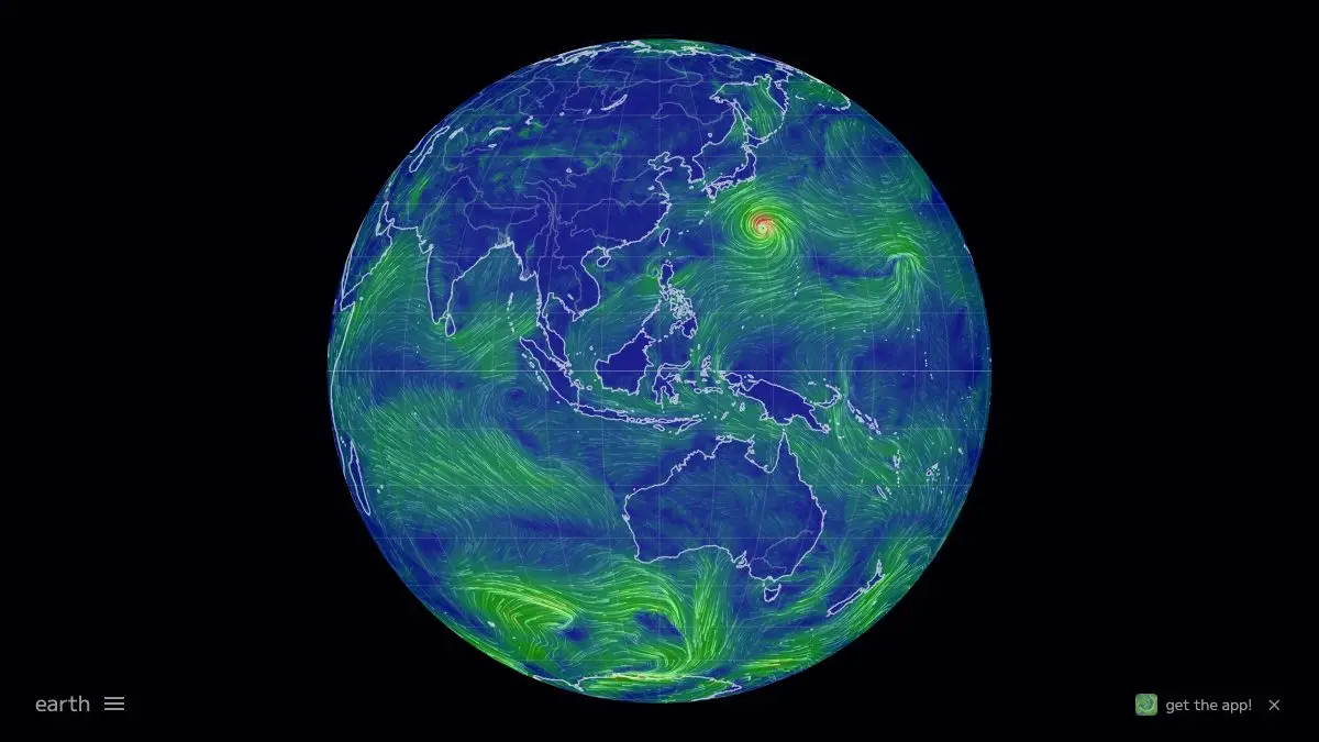
earth :: nullschool is a 3D globe showing the planet’s wind, weather and ocean currents as live, flowing particles. Drag to spin it. Scroll to zoom. Watch the jet stream tear across the Pacific and the trade winds curl into the equator. It updates from real forecast data, and it is completely free.
There is no tutorial, no signup, no cookie banner. Just Earth, moving.
What is earth :: nullschool?
Built by developer Cameron Beccario, it takes public meteorological and oceanographic datasets and renders them as thousands of animated streamlines over a globe you can grab with your mouse. The result sits somewhere between a scientific instrument and an aquarium screensaver, and it does both jobs unreasonably well.
The interface is deliberately almost invisible. The only visible control on earth :: nullschool is the small word “earth” in the bottom-left corner. Click it and a control panel unfolds with more depth than the minimal design suggests: modes for air, ocean, particulates and chemistry, atmospheric heights from the surface up to the stratosphere, overlays for temperature, humidity, pressure and wind speed, and a genuinely absurd list of map projections.
Then you close the panel and it goes back to being a beautiful, silent, spinning planet.
What can you do on earth :: nullschool?
- Watch global wind at any altitude. Surface winds show weather you feel. Climb to the 250 hPa level and the jet streams appear as roaring rivers of air circling the hemispheres.
- Switch to ocean mode. Ocean currents animate as slow, thick swirls: the Gulf Stream, the Kuroshio, the Antarctic Circumpolar Current all clearly visible as the machinery of the climate.
- Look at air quality. Particulate layers show dust storms leaving the Sahara and smoke plumes from wildfires drifting across continents.
- Overlay temperature or humidity. Wind lines on a colored temperature field is where the globe turns from pretty into genuinely explanatory.
- Click anywhere for numbers. Tap a spot and a readout gives the exact wind speed, direction and overlay value at that point.
- Change projection. Orthographic globe, flat equirectangular, Waterman butterfly, stereographic, conic. The polar views in particular reframe how the atmosphere is organized.
Tips to get the most out of it
Go straight to the 250 hPa height. Open the panel, set height to 250, and look at the northern hemisphere. That is the jet stream, and once you have seen it you will understand weather forecasts differently forever.
Spin the globe to a pole. Grab it and drag until you are looking straight down on the Arctic or Antarctic. The polar vortex spinning below you is worth the trip.
Try ocean mode with the currents animation. It is slower and heavier than wind and somehow more meditative. Follow the Gulf Stream from Florida to Norway and it becomes very obvious why Britain is not as cold as Labrador.
Check after a big event. Wildfire season, a dust outbreak, a hurricane, switch to the relevant layer within a day or two and you can watch the plume or the storm on the globe itself.
Use it on a phone. The touch controls are excellent, the whole thing runs smoothly, and it makes an unbeatable “look at this” for anyone standing near you.
Note the timestamp. The panel shows the data time. Different layers refresh on different cadences, so a current-looking ocean view may be a few days old while the wind is hours fresh.
If you like earth :: nullschool, also try…
- Windy: the same data with far more layers, forecasts and tools, on a conventional map.
- Blitzortung Lightning Map: every lightning strike on the planet appearing live.
- Flightradar24: aircraft riding the winds you just watched.
- Scale of the Universe: when one planet is no longer enough perspective.
Our full Maps & Exploration collection has plenty more globes to spin.
Frequently asked questions
What is earth :: nullschool?
earth :: nullschool is a free interactive visualization of global weather conditions rendered on a spinnable 3D globe. It animates live wind, ocean currents, waves, temperature, air quality and other atmospheric data as flowing particles over the planet. It was created by Cameron Beccario and its source code is openly available.
Is earth :: nullschool free?
Yes, completely free with no account, no signup and no ads. It runs entirely in a browser on desktop and mobile, and the project's code is published as open source.
Where does the data come from?
The globe is built from public forecast and observation datasets, including global weather models for wind and temperature, ocean current and wave data, and satellite-derived measurements for particulates and chemistry layers. Different layers refresh on different schedules, and the timestamp shown in the control panel tells you how current the view is.
How do I change what earth :: nullschool is showing?
Click the word 'earth' in the bottom-left corner to open the control panel. From there you can switch between air, ocean, particulate and chemistry modes, change the height in the atmosphere, pick an overlay such as temperature or wind speed, and choose from many map projections including a flat view and a classic globe.